


Services

1- Hard Data is Key:
Understanding and incorporating 2D data, whether from surface field work or underground mine
mapping,
should always be the starting point of an integrated and coherent 3D geologic model, especially
for areas
with great geometric contrasts. Without this valuable data, 3D modelling is essentially
performed with
blinders on, and its absence results in a model that is too theory-driven, and lacks input from
geologists
and “real” field data.
2- Database Management and Validation:
Three-dimensional geologic models require complete, homogeneous and valid databases. The
resulting 3D
models are directly based on and rely on high-quality data. The data comprises both surface and
underground observations. “Raw” or “hard” data should always be assigned more weight and act as
rigid
control points in 3D models. Hard data should always be distinguishable from interpreted data in
3D
models. Investing the necessary time to learn how to homogenize and structure raw data in a
rigorous way will be paid back during the 3D interpretation process.
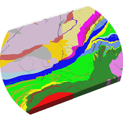
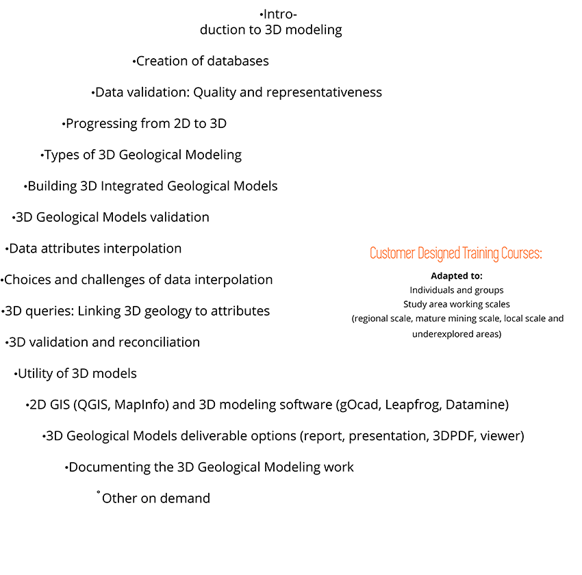
3- 3D Geological Modeling:
High-quality validated databases are used as groundworks to both lithological and structural
interpretations
to be used for the 3D geological modelling. Constrain the geological model to the geological
surface mapping
data to help define the studied area’s main structural fractures (first and second order faults,
shear zones,
deformation corridors, etc.). True and realistic 3D interpretation for different geological
environments,
structural settings and metallogenic styles. Hence, 3D geological modeling adapted to your
deposit
and host rocks.
4- Different scale queries and targets characterizations:
Once 3D models are completed, they should be used as an exploration tool, populating their cells
with
user-chosen properties. Both quantitative and qualitative properties can be interpolated
throughout the cells
of the 3D model for further querying and questioning. Extensive geostatistical analysis is
thoroughly done for
all the attributes to be used in the querying and targeting processes. Thus, the extra benefit
of 3D map models
is their use as dynamic interactive tools to help define new mineral exploration targets at
depth.
5- Robust 3D Integrated Geological Models:
A 3D map model is not a goal but a tool that should be dynamic, modified, questioned, shared and
updated.
Its future usefulness is determined by how well it can be utilized by a multi-disciplinary team
of geologists,
geophysicists, geochemists, engineers, metallurgists and environmental experts.


Here at “FF Explore 3D” we are innovative people that are more
than just numbers and data.
Our love for this work is full of passion & dedication!
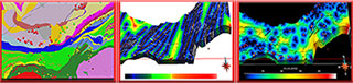
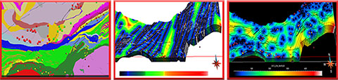
Here is a little overview of our 3D geological modelling methodology!
Here is a little overview of our 3D geological modelling methodology!
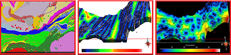
The development of robust 3-D geological models involves the integration
of large amounts of public geological data, as well as additional accessible
proprietary lithological, structural, geochemical, geophysical, and diamond drill holes
data.
The main advantages of this technique for the mining industry are the homogeneity of data treatment and the validation of geological interpretations, taking into account geophysical and geochemical data. Data integration and cross-correlation of geology and geophysics can be achieved in two dimensions in any good GIS package. However, the added strength of 3-D analysis is the integration of separate data sets in three dimensions to build more complete, more realistic models, and in delineating areas of high economic potential at depth. Furthermore, these models can be modified and improved at any time by adding new data from ongoing drilling and geoscientific surveys.
The main advantages of this technique for the mining industry are the homogeneity of data treatment and the validation of geological interpretations, taking into account geophysical and geochemical data. Data integration and cross-correlation of geology and geophysics can be achieved in two dimensions in any good GIS package. However, the added strength of 3-D analysis is the integration of separate data sets in three dimensions to build more complete, more realistic models, and in delineating areas of high economic potential at depth. Furthermore, these models can be modified and improved at any time by adding new data from ongoing drilling and geoscientific surveys.


Francine Fallara is a dedicated and innovative professional exploration geologist with
over 30 years of experience in diverse challenging geological exploration environments.
She is an analytical senior consultant with extensive field-based experience skilled in successfully navigating complex geological exploration studies across Quebec (James Bay, Abitibi-Temiscamingue and Beauce), Maritimes and Nunavut.
3D geological modelling and numerical mineral targeting expertise, since 2000, including structural interpretations and queries, applied geochemical methods and alteration characterization for geological exploration, database managing and GIS data processing.
Between 2012 and 2019 senior 3D exploration geologist for major companies (Osisko Mining, InnovExplo Consultants, Agnico Eagle Exploration, Falco Resources, QMX Gold Mines, Alexis Minerals).
Between 2000-2012 3D exploration geologist for various private exploration companies, public and research group projects.
1989-2003 field exploration geologist for regional and detailed metallogenic cartography surveys.
Member of the Ordre des Géologues du Québec since 2002.
Graduated as a geologist (B.Sc.) from Laval University (1993) and has a Master degree in metallogeny (M.Sc.A) from INRS and Quebec University (UQ-1996) in Quebec City.
Contact!
Phone: 1-819-856-6748
Email: Info@ffexplore3d.com
Web: www.ffexplore3d.com
Quebec City, Quebec Canada
Email: Info@ffexplore3d.com
Web: www.ffexplore3d.com
Quebec City, Quebec Canada


Powered by